The many forts, rocks, springs and other landmarks along the Oregon Trail kept settlers from losing not just their direction, but their hope as well.
These days, most people don’t pack up and move unless they have a job waiting for them. But for half a million overland emigrants in 19th century America, that wasn’t the case. Not only were there no future jobs secured, there were no turnkey two-bedroom apartments either.
When travelers gazed across 2,000 miles of bleak prairie ahead, often avoiding the cholera epidemic and other trail dangers, there was nothing ahead to light their way and give them hope – nothing but the chance to start fresh and the next landmark on the trail.
With such little waiting for them, Oregon Trail and California Trail travelers depended on these landmarks: without them, there was no sign of progress toward their dreams.
The Beginning of the Oregon Trail
When they embarked on the long trip west, almost everyone kicked off their journey at or near Independence, Missouri. From there, though, the trail widened. Travelers could be nearly parallel and have no knowledge of each other.
Most people think of the Oregon Trail as a simple worn two-track across the plains, but as historian Aubrey L. Hanes says, it was actually more of a “travel corridor.” In many places the Oregon Trail could be more than a mile wide.
Nevertheless, everyone’s journey was marked by several landmarks, the importance of which cannot be overstated. The monotony of life on the Oregon Trail was oppressive, but every time they spotted a landmark, it was a sign that they were making progress, and that they weren’t lost.
Landmarks on the Oregon Trail
1. Fort Kearny

After a short time on the trail, emigrants rolled into Fort Kearny. Built in 1848, this humble cluster of adobe buildings gave them the opportunity to restock forgotten or used supplies, re-shoe their animals, and pass along letters for the postman.
2. Ash Hollow Complex
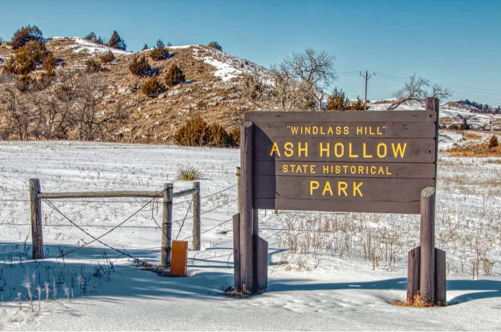
Ash Hollow was a favorite campsite, offering plenty of wood, clean water, and ample grazing for their animals. But it came with a steep price – travelers had to drive their wagons 300 feet down the nearly vertical Windlass Hill.
More than a few parties lost oxen and wagons to the perilous 25-degree slope. Many tried to let their wagons down more gently by chaining the wheels or dragging a small tree behind them for resistance.
Here we were obliged, from the steepness of the road, to let the wagons down by ropes…”
Howard Stansbury, July 3, 1852
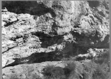
3. Courthouse and Jail Rocks

This large butte, which emigrants thought resembled the courthouses back East, along with the smaller rock beside it, were the first of several remarkable rock formations on the trail.
Located near present-day Bridgeport, Nebraska, these hulking pillars still mark the way for travelers on State Route 88.
Related read: 7 Tantalizing Stories of Lost Treasure in Oregon
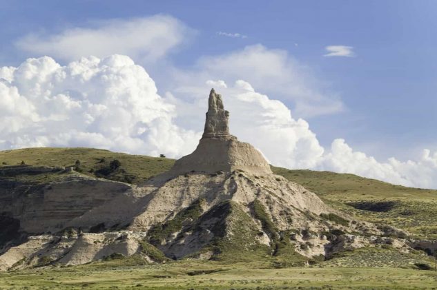
4. Chimney Rock

Formed from loose clay and volcanic ash, this sky-piercing spire was one of the most noted landmarks in travelers’ diaries. Emigrants could see Chimney Rock on the horizon for days before they reached it. Originally 425-feet tall, it’s rumored that some soldiers used it for target practice, shaving at least 30 feet off the top with a cannonball.
No conception can be formed of the magnitude of this grand work of nature until you stand at its base and look up. If a man does not feel like an insect then I don’t know when he should.”
Elisha Perkins, June 27, 1849
5. Scotts Bluff
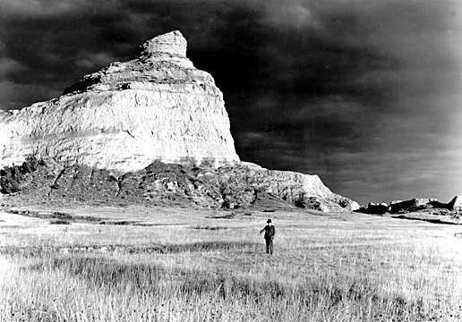
The next landmark travelers looked for was Scotts Bluff, a large rock plateau along the North Platte River. Named for fur trader Hiram Scott, whose skeleton was found at its base in the 1820s, the bluff was one of the most commonly mentioned in emigrant journals.
Before 1851, the only way past Scotts Bluff was by way of Robidoux Pass, several miles out of the way. In 1851, the army improved the route by creating Mitchell Pass.
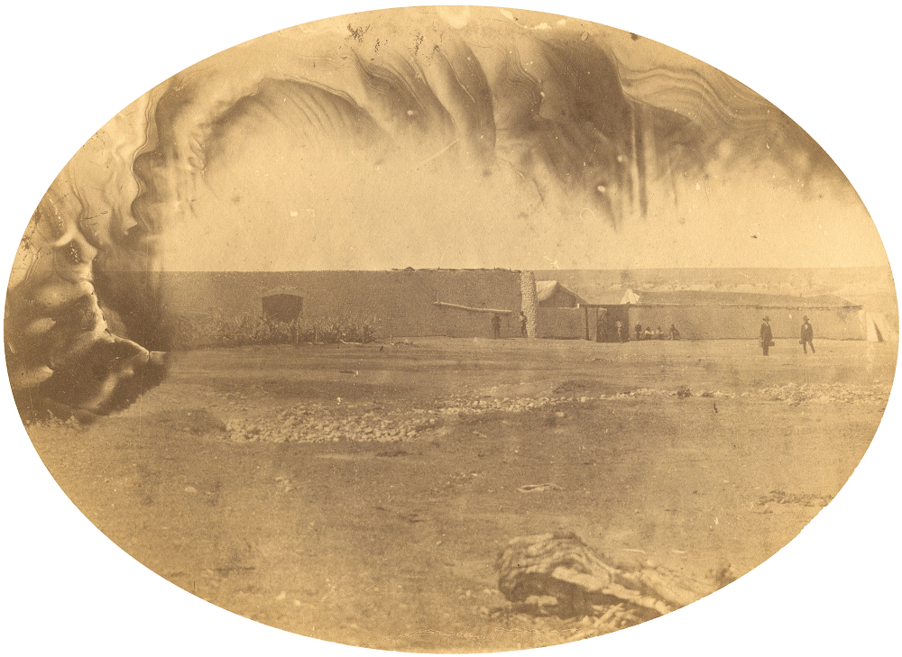
6. Fort Laramie
Another fur trading post turned military outpost, Fort Laramie was located at the edge of today’s Wyoming. Originally built by trader William Sublette in 1834, the fort cycled through many names. First, it was Fort William.
Then, when the American Fur Company bought it, they spruced it up and renamed it Fort John. The name didn’t stick, however, and the fort became known as Fort Laramie, after French-Canadian trapper Jacques LaRames.
Overland emigrants had yet another name for Fort Laramie: they jokingly referred to it as “Camp Sacrifice” in honor of all the abandoned furniture and supplies littering the trail nearby. As their Oxen wore out, travelers were forced to lighten their loads, tossing everything from books to bureaus out the backs of their wagons.
Fort Laramie was another important restocking point for travelers, who were able to freshen up their supplies, check in with a blacksmith, and repair their wagons. Such demand had an explosive effect on prices, however – emigrants could expect to pay 20 times what they would have back East.
This fort is of adobe, enclosed with a high wall of the same. The entrance is a hole in the wall just large enough for a person to crawl through. The impression you have on entering is that you are in a small town. Men were engaged in all kinds of business from blacksmith up. We stayed here some time looking at everything that was to be seen and enjoying it to the fullest extent after our long tramp. We camped one mile from the fort, where we remained a few days to wash and lighten up.”
Sallie Hester, June 19, 1849
When they left Fort Laramie, travelers set out across Wyoming’s vast, dry prairie. Many toted along as much fresh water as they could carry; they would find nothing but poisoned alkali water for miles, until they reached the fresh, cool water of the aptly named Sweetwater River.
7. Independence Rock
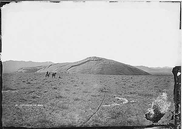
Next on their journey, emigrants came to yet another hulking rock formation. Independence Rock, also known as the “Great Desert Register,” sprang up 128 feet high and stretched a mile long. More than 5,000 emigrants scratched their names on its surface or smeared their signatures in wagon grease along the side.
Reached Independence Rock; at a distance looks like a huge whale. It is being painted and marked every way, all over, with names, dates, initials, &c – so that it was with difficulty I could find a place to inscribe it.”
J. Goldsborough Bruff, July 26, 1849
Nobody really knows why it’s called Independence Rock, but experts have a few theories. Maybe it’s because it stands alone, independent from other formations. Or perhaps it’s because early trappers spent their 4th of July holidays at the rock, or because overland emigrants tried to reach the rock by Independence Day to avoid snow in the mountains they would later cross.
Maybe the rock represents the independence they sought out west, the freedom gained by starting over.
Regardless of where it got its name, Independence Rock remains one of America’s most significant landmarks – a symbol of courage and exploration. Wyoming State Parks maintains a visiting site on State Route 220 near Alcova, Wyoming.
8. Devil’s Gate
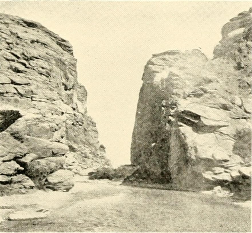
A few miles southwest of Independence Rock, travelers reached Devil’s Gate, a formidable rock canyon, 370 feet high. The narrow crevice made way for the Sweetwater River, but not much else.
Travelers had to go around the canyon, but not before scribbling their names (again) on its granite walls.
9. South Pass
This grassy mountain passage was the most underrated landmark along the trail. It signified the journey’s halfway mark, as well as the highest point. Compared to some of the steeper treks they had made, like at Windlass Hill, the South Pass was downright gentle.
Many didn’t even notice that they weren’t on flat land, but almost everyone took a moment to acknowledge that if it weren’t for the South Pass through the Rocky Mountains, there would likely be no westward migration. It was thanks to this humble opening in the Rockies that Oregon Trail pioneers could chase their futures towards the Pacific.
Up a very gentle ascent to the SOUTH PASS OF THE ROCKY MOUNTAINS, or the dividing ridge separating the waters of the Atlantic and the Pacific. The ascent to the pass is so gradual, that but for our geographical knowledge; we should not have been conscious that we had ascended to, and were standing upon the summit of the Rocky Mountains – the backbone – of the North American Continent.”
Edwin Bryant, July 12, 1846
10. Fort Bridger
After the South Pass, most travelers continued southwest on the main trail past Fort Bridger. In 1843, Jim Bridger and Louis Vasquez built the rough little fort to trade with Indians and sell supplies to overland emigrants.
Although it was a much-looked-forward-to landmark along the trail, it didn’t have much to offer the weary travelers. Fort Bridger was really just a couple of wooden shacks – nothing like the comparatively metropolitan Fort Laramie.
It was near Fort Bridger that the Mormon Trail branched off toward the Great Salt Lake. Some travelers coming out of the South Pass chose to take Sublette’s Cutoff instead, bypassing Fort Bridger. The notorious shortcut saved 75 miles but cut through a perilous desert. Many of its travelers lost animals, wagons, and loved ones in the parched prairie.
11. Soda Springs
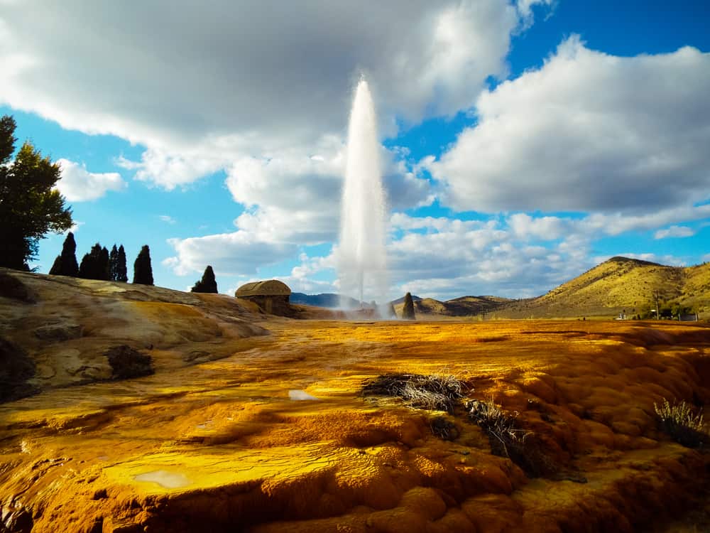
Near where Sublette’s Cutoff and the main trail reunited, travelers came upon Soda Springs in the Bear River Valley. Bubbling springs and geysers spouted all over in a landscape marred with craters and mineral formations. Emigrants tasted the carbonated water, some even adding flavorings. A few claimed that the waters were intoxicating, like beer.
Usually somewhere near Soda Springs, travelers parted ways – some to Oregon, some to California, and some to another adventure altogether.
Passed Soda Springs. Two miles further on are the Steamboat Springs. They puff and blow and throw the water high in the air. The springs are in the midst of a grove of trees, a beautiful and romantic spot.”
Sallie Hester, July 29, 1849
12. Fort Hall and The Gate of Death

From Soda Springs, settlers traveled on to Fort Hall near the Snake River. Originally built as a fur trading post by Nathaniel Wyeth in 1834, the fort became yet another pantry-bolstering stop on the overland trail.
Fort Hall was another popular “parting of the ways” point. After traveling hundreds of miles together, friends said good-bye and good luck to those headed another direction.
After leaving Fort Hall, the Willamette Valley-bound travelers followed the winding snake river through the Gate of Death, a narrow rock canyon feared for its vulnerability to ambush.
13. Three Island Crossing

In Idaho, three gravel banks interrupt the snake river, providing the chance for overland emigrants to leap-frog across the dangerous river if the water wasn’t too high.
Even when the Snake was at its lowest, fording the river at Three Island Crossing was treacherous, and many didn’t survive. About half of all travelers decided not to risk it, opting instead for the longer dry rocky route along the south bank.
In 1869, Gus Glenn installed a ferry a couple miles upstream, making river hopscotch unnecessary.
14. Fort Boise

Fort Boise was established as a Hudson’s Bay Company outpost in 1834 by Thomas McKay. Located on the border of present-day Oregon, the fort boosted trade and reminded travelers: “You’re getting closer.”
15. The Dalles
With roughly only 100 miles left in their journey to Oregon country, the emigrants faced one of the most daunting tasks yet: crossing the Columbia River at the Dalles rapids. Travelers piled their wobbly wagons onto a rickety raft and rode it into whitewater.
In 1843, N.M. Bogart wrote, “When trying to pass some of the Cascades their frail craft would get caught in one of the many whirlpools, the water dashing over them, and drenching them through and through.”
Many emigrants capsized in the Columbia and lost everything, after painstakingly packing it across the plains for 2,000 miles. But even those were the lucky ones – some had persevered through all the previous perils of the overland journey, only to perish at the Dalles.
Fortunately, by 1846, Samuel Barlow had cleared an alternate route. For a precious five dollars per wagon, settlers could avoid the rapids altogether. Most chose to travel on Barlow’s toll road.
16. Fort Vancouver and Oregon City

For most Oregon Trail travelers, Fort Vancouver was the end of the line. Perched on the north bank of the Columbia River, Fort Vancouver was a large British outpost as well as the headquarters of the Hudson’s Bay Company.
Until John McLoughlin set up his Oregon City General Store in 1846, settlers stopped at Fort Vancouver for supplies before heading out to their homestead, their own pot of gold at the end of a colorful and harrowing journey.
California Trail Landmarks

After the “parting of the ways,” travelers on the California Trail passed a few landmarks as well before arriving at their destination. California settlers beheld the Humboldt River, the Sierra Nevada Mountains, and Lake Tahoe, finally arriving at Sutter’s Fort near present-day Sacramento.
The Journey’s End
Through these landmarks, the land guided about 500,000 emigrants west. But the travelers made their marks on the land as well, leaving behind a trail of notes, warnings, ox skulls, shallow graves, and the inevitable trash that accompanies a mass exodus.
These days, much of the West is taken over by skyscrapers, or at the very least, neatly plowed fields. But history fans with wandering feet can still visit most of the original Oregon Trail landmarks and pay homage to old milestones.
If it weren’t for those landmarks, travelers might still be aimlessly wandering the Great American Desert and sending their luggage west the long way around Cape Horn.
Sources & Further Reading
- The Oregon Trail: A New American Journey, Rinker Buck
- Moon Oregon Trail Road Trip: Historic Sites, Small Towns, and Scenic Landscapes Along the Legendary Westward Route, Katrina Emery
- The Oregon Trail: An American Saga, David Dary
Molly Jacobson is a freelance journalist based near Miles City, Montana, where she wrangles five babies, twenty chickens, and one emotionally unstable dog. She has a B.A. in Psychology from Gonzaga University and writes for mental health blogs, history websites, two local newspapers, and anyone else who doesn't mind her flagrant abuse of the maximum allowed word count.


thank you for information
AMAZINGGGGGGGGGGGGGG